I came across a plugin last week that made me say “why doesn’t everyone have this?”
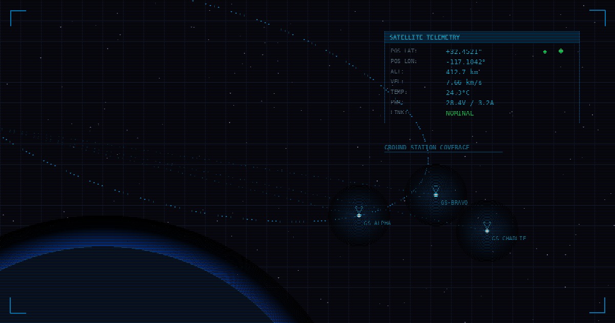
Clay Anderson built openc3-cosmos-map, a plugin for OpenC3 COSMOS that shows satellite positions on an interactive map. Right inside your mission control interface. Updating in real-time.
That’s it. That’s the plugin. And it’s exactly what we need for training.
The Problem I Didn’t Know I Had
We’ve been using GPredict for satellite tracking in our courses since the beginning. It works great. Students learn orbital mechanics, predict passes, schedule contacts. All good.
But here’s the thing: they’re constantly alt-tabbing. GPredict over here, COSMOS over there. “Where’s the satellite right now?” Tab. “What’s the telemetry showing?” Tab. “Is this pass almost over?” Tab.
The mental overhead adds up. Students are trying to learn space security concepts, but they’re spending brain cycles just keeping track of where things are.
Clay’s plugin fixes this by putting the map right where you’re already looking.
Why I’m Excited About This
When you’re teaching someone to attack or defend a space system, geometry matters. A lot.
“Which ground stations could intercept this uplink?” is a question with a real answer. You can calculate it. But watching a satellite approach a ground station’s coverage circle, seeing it enter range, and then watching telemetry start flowing? That’s different. That clicks.
Same thing with timing attacks. In our offensive course, students need to inject commands during a specific orbital window. With separate tools, they calculate the pass time and watch the clock. With the map integrated into COSMOS, they watch the satellite approach and time their actions to what they see.
It sounds small. It’s not.
What We’re Doing With It
We’re in the process of integrating this plugin into our lab environment. The goal is to have it running for our next round of courses.
I don’t have benchmarks or detailed test results yet. I’ve just been playing with it in our dev environment, and it does exactly what it says on the tin. Position data from COSMOS, rendered on a map, updating live.
There are probably edge cases and configuration quirks I’ll run into. That’s fine. The core concept is solid, and Clay’s already done the hard work of building the integration.
If You Want to Try It
The repo is here: github.com/clayandgen/openc3-cosmos-map
If you’re already running OpenC3 COSMOS, it should be straightforward to install. If you’re not running COSMOS yet, well, that’s a whole separate rabbit hole (a fun one, but budget some time).
Big thanks to Clay Anderson for building this and making it available. Open source tooling for space operations is still pretty sparse compared to other domains, so contributions like this really matter.
I’ll probably post an update once we’ve got it fully integrated and have put some students through it. For now, I just wanted to share the find.